Mapping Data
In addition to questionnaires,
CARA can supplement your data collection needs with the construction of high quality, easy to read maps.
For additional information on the use of computer-aided mapping for your research needs, contact CARA researcher, Dr. Mark Gray.
National Mapping:
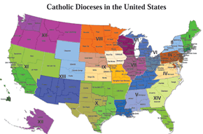
CARA produces the map that is published annually in The Official Catholic Directory. This 11″ by 17″ color map displays all territorial Latin Rite dioceses and archdioceses in the United States as well as the Episcopal sees and USCCB regions. To order this map, click here ($15.00 including shipping). A 24″ by 36″ color map is also available for $65 including shipping.
This map can be designed to include additional data points depending on your mapping needs, including the churches and cathedrals in a dioceses, the Catholic schools located in a region, and other important institutional locations relative to the Catholic church nationally.
Local Mapping
CARA creates maps at all levels of geography to enable clients to view the geo-spatial aspects of their ministry. For example, parishes can view the geographic distribution of their parishioners on a zip-code level map, pastoral planners can observe the concentration of Hispanics within their diocese on a county-level map, and Catholic news organizations can use a state-level national map to illustrate the location of Catholic colleges and universities in the United States. Depending on your research needs, CARA can present data in a map format that is easy to read and understand.